JacketFlap connects you to the work of more than 200,000 authors, illustrators, publishers and other creators of books for Children and Young Adults. The site is updated daily with information about every book, author, illustrator, and publisher in the children's / young adult book industry. Members include published authors and illustrators, librarians, agents, editors, publicists, booksellers, publishers and fans. Join now (it's free).
Login or Register for free to create your own customized page of blog posts from your favorite blogs. You can also add blogs by clicking the "Add to MyJacketFlap" links next to the blog name in each post.
Blog Posts by Tag
In the past 7 days
Blog Posts by Date
Click days in this calendar to see posts by day or month
Viewing: Blog Posts Tagged with: cultural anthropology, Most Recent at Top [Help]
Results 1 - 2 of 2
How to use this Page
You are viewing the most recent posts tagged with the words: cultural anthropology in the JacketFlap blog reader. What is a tag? Think of a tag as a keyword or category label. Tags can both help you find posts on JacketFlap.com as well as provide an easy way for you to "remember" and classify posts for later recall. Try adding a tag yourself by clicking "Add a tag" below a post's header. Scroll down through the list of Recent Posts in the left column and click on a post title that sounds interesting. You can view all posts from a specific blog by clicking the Blog name in the right column, or you can click a 'More Posts from this Blog' link in any individual post.
Professor Sidney Mintz passed away on 26 December 2015, at the age of 93. “Sid” as he was affectionately called by his acquaintances, taught for two decades at Yale University and went on to found the Anthropology Department at Johns Hopkins. His best-known work, Sweetness and Power: The Place of Sugar in Modern History, was published in 1985.
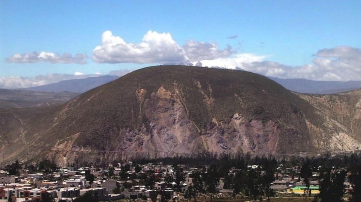
On 12 August 2014 at precisely 2:58 a.m., a 5.1 earthquake struck, centered at the hilltop lightning huaca San Catequilla de Pichincha. Since this initial earthquake, there have been 57 aftershocks, all centered at or close to this hill. Cerro Catequilla is situated where the Río Monjas empties into the Río Guayllabamba, approximately 15 kilometers north of Quito in the Pomasqui Valley directly east of the town of San Antonio. This is the only known Inca huaca located directly under the equator at 0°0’02″ S by 78°25’43″ W at 2,683 meters above sea level, making this the paradigmatic place of the astral positioning. The southern terminus of the summit is situated directly on the Mitad del Mundo at the equator, 0º0’00” S, beside a series of natural springs. The mountains surrounding Cerro Cetquilla range from 3,000 to 4,000 meters above sea level and the Cerro Pululagua volcano is located due west.
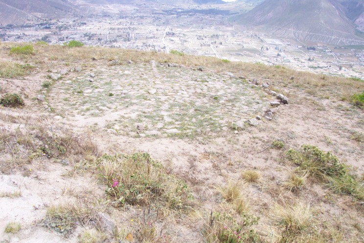
Northwest circular platform. The small circular platform is still visible on the summit of San Catequilla, as it appeared in July 2008. Photo by John E. Staller.
Volcanoes have symbolic associations to lightning and the importance of this valley is evidenced by the two branches of the Inca road, or Camino Real, one to the east and the other to the west side of the hill. Numerous Inca sites are in the surrounding landscape, including Pucara de Rumicucho, an Inca fortress and administrative center. The lightning huaca is made up of two superimposed earthen platforms; a buried rectangular platform measuring about 100 meters N/S and about 80 meters E/W, below a large circular earthen platform measuring 60 meters in diameter. The locations of these superimposed platforms on the southwestern slopes of Cerro Catequilla are the only places on the 200-meter long hilltop where the equator is directly overhead. This is one of three Inca huacas with Catequilla toponyms between the equator and 3° N. Catequilla de Pichincha was the most highly venerated because of its location under the equator.
In 1609, the chronicler Garcilaso de la Vega stated that the pillars and columns on many platforms around Quito and to the north in Cayambe and Ibarra were “broken to pieces” by the Conquistador Sebastián de Benalcázar, who tore them all down because the Andeans worshiped them idolatrously. There is very little information in the Spanish chronicles or from the Audiencia de Quito on how temporal cycles were recorded in and around Quito during the Contact Period. Most scholars have found astronomical calculation regarding the solar calendar was achieved through shadow casting. The most highly venerated gnome was Catequilla de Pichincha, primarily because when the sun was overhead during certain parts of the annual cycle there was increasingly diminished shadow around the pillar or gnome at this lightning huaca.
Cerro Catequilla, Pichincha Province, Ecuador, looking east from the town of San Antonio. Archaeological evidence of earlier occupation pertaining to Panzaleo culture at the base of the hill and the earthen architecture at the huaca on the summit suggests it was venerated before Inca expansion into this region. Cerro Catequilla stands at 2638 masl at the southern terminus of the summit directly under the Mitad del Mundo, or the equator. Indigenous informants mentioned that only maize may be cultivated on the summit and every year around the December solstice, rituals are still carried out and offerings are made to thehuaca. Photo courtesy of Cristóbal Cobo.
The Inca constructed over a hundred ceremonial platforms and shrines (villcas), some on mountain passes (apachitas), others on the summits of the highest mountains in their empire, between 1438 and the Spanish Conquest in 1532. Lightning was the major theophany of weather in Inca religion, known as Ilapa, now Illapa, the Hispanic spelling. Huacas with “Catequil” or “Catequilla” toponyms were associated with the spread of Catequil, a religious cult to lightning throughout their empire. Lightning veneration extended from Quito to Cuzco during the early Colonial Period. The principal huaca associated with lightning, was another hilltop huaca in northern highland Peru, Catequil de Huamacucho, a huaca said to make other huacas “speak,” and therefore believed to have the ability to predict earthquakes. Spirits associated with lightning are malevolent, have ancient origins in Andean cosmology and religion, and are symbolically depicted in various cultural traditions.
Many lightning huacas around the equator and regions to the north have circular stone enclosures or platforms which local Andean informants have said to me are places where lightning struck and are therefore sanctified. Such features have also been identified archaeologically in and around the nearby Inca fortress at Pucara de Rumicucho. Circular stone enclosures or platform features generally measure between three to four meters in diameter and are dispersed throughout this region. However, these were not destroyed by the Spanish conquistadores because they were not venerated in an “idolatrous” manner. Some are located in indigenous towns in the surrounding valley and those in the nearby towns are clearly visible from the summit of Cerro Catequilla. My preliminary research at this site indicates that such features also had astronomical function in association with sight lines to the surrounding horizon, solar cycles, and constellations in the night sky. In the Andes, thunder and lightning have symbolic associations with rain, hail, earthquakes, and the metallurgical arts, particularly gold and silver, agricultural fertility, and fire and damaging hail storms.
Featured image: Andean landscape, north of Quito. This photo is looking north across Cerro Catequilla and was taken from the lightning huaca at 0°.00 latitude. This valley has historically been of critical importance to cultivation, transport, and the movement people and food crops into northern Ecuador and Colombia. Photo by John E. Staller.