JacketFlap connects you to the work of more than 200,000 authors, illustrators, publishers and other creators of books for Children and Young Adults. The site is updated daily with information about every book, author, illustrator, and publisher in the children's / young adult book industry. Members include published authors and illustrators, librarians, agents, editors, publicists, booksellers, publishers and fans. Join now (it's free).
Login or Register for free to create your own customized page of blog posts from your favorite blogs. You can also add blogs by clicking the "Add to MyJacketFlap" links next to the blog name in each post.
Blog Posts by Tag
In the past 7 days
Blog Posts by Date
Click days in this calendar to see posts by day or month
Viewing: Blog Posts Tagged with: atlas, Most Recent at Top [Help]
Results 1 - 25 of 43
How to use this Page
You are viewing the most recent posts tagged with the words: atlas in the JacketFlap blog reader. What is a tag? Think of a tag as a keyword or category label. Tags can both help you find posts on JacketFlap.com as well as provide an easy way for you to "remember" and classify posts for later recall. Try adding a tag yourself by clicking "Add a tag" below a post's header. Scroll down through the list of Recent Posts in the left column and click on a post title that sounds interesting. You can view all posts from a specific blog by clicking the Blog name in the right column, or you can click a 'More Posts from this Blog' link in any individual post.
Quite a lot has happened in 2016. The year has flew by with history making events such as the Brexit, the Presidential election in the United States, and the blockade of Aleppo to name a few.
With the ballots cast and the year winding down, we recognize Nepal as Oxford's Place of the Year 2015. The country came into the global spotlight back in April, when a devastating earthquake took over 9,000 lives and left hundreds of thousands of people homeless. Months later, critics point at the slow-moving recovery process that has still a far way to go before Nepal can resume normal operations.
You don't need to follow the news too closely to know that 2015 has been a roller coaster of a year. Last week we announced our longlist for Place of the Year 2015, but since then some of you have been asking, "why is x included?", or "why is y worth our attention?"
Today we officially launch our efforts to discover what should be the Place of the Year 2015, coinciding with the publication of the Atlas of the World, 22nd edition--the only atlas that's updated annually to reflect current events and politics.
With the announcement of Scotland as Place of the Year for 2014, we’re looking back at some of the key events that put Scotland in the news this year. News of the Scottish Independence Referendum dominated the headlines, and politicians, economists, and analysts discussed and debated Scotland’s role both in Europe and on the global market. However, a number of other important events also put Scotland in the news this year, including playing host to multiple sporting events, passing a bill that will legalize marriage in December 2014, and seeing the first female First Minister of Scotland take office. Here is a look back at Scotland in 2014, in pictures.
February 2014: Scottish Parliament votes in favor of same-sex marriage
In February 2014, Scottish Parliament votes overwhelmingly in favor of a bill that would legalize same-sex marriage. The bill received Royal Assent on 12 March, and will take effect in December 2014. (Image: Rainbow flag breeze by Benson Kua. CC-BY-SA-2.0 via Wikimedia Commons.
June 2014: the 700th anniversary of the Battle of Bannockburn
June 2014 marked the 700th anniversary of the Battle of Bannockburn, which saw a victory for Scotland in the First War of Scottish Independence in 1314. (Image: Battle of Bannockburn from a 1440s manuscript of Walter Bower’s Scotichronicon. Public domain via Wikimedia Commons.)
July-August 2014: the 2014 Commonwealth Games are held in Glasgow
The XX Commonwealth Games took place in July and August 2014 in Glasgow. Athletes and fans from all over the world descended on the city to compete for and cheer on their teams. Teams with the highest medal count were England, Australia, and Canada, with Scotland coming fourth. (Image: Commonwealth Games 2014 by Graham Campbell. CC-BY-SA-2.0 via Wikimedia Commons.)
September 2014: the Scottish Independence Referendum is held
After Scottish residents vote “no” in the referendum, Alex Salmond announced his resignation as First Minister of Scotland and leader of the Scottish National Party. (Image: Alex Salmond in 2007 by the Scottish Government. CC-BY-2.0 via Wikimedia Commons.)
September 2014: the Ryder Cup takes place at Gleneagles
Scotland held a second major international sporting event in 2014, the 40th Ryder Cup, which was held at the Gleneagles Hotel near Auchterarder in Perthshire. (Image: Gleneagles Hotel and grounds by Simon Ledingham. CC-BY-SA-2.0 via Wikimedia Commons.)
November 2014: Nicola Sturgeon succeeds Alex Salmond
Nicola Sturgeon succeeded Alex Salmond as leader of the Scottish National Party and First Minister of Scotland after she was the only candidate to put their name forward in the party’s leadership election. She is the the first woman to hold either of these positions. (Image: Nicola Sturgeon by The Scottish Government. Open Government Licence v1.0 via Wikimedia Commons.
December 2014: Dundee is named the UK's first UNESCO City of Design
In December 2014, Dundee became the UK’s first UNESCO City of Design, for its “diverse contributions to fields including medical research, comics, and video games,” according to BBC News. (Image: Midsummer night by Val Vannet. CC-BY-SA-2.0 via Wikimedia Commons.
As voting for the shortlist came to a close, Scotland took home the title of Oxford’s Place of the Year 2014. This region of the United Kingdom came into spotlight when nearly half its citizens fought to pass the Scottish independence referendum, which would have allowed Scotland to declare itself as an independent country.
But what happened in September wasn’t Scotland’s first effort to break away from the United Kingdom. Back in 1979, the majority of Scottish residents were in favor of devolution, which would pass the powers of the Parliament of the United Kingdom over to the Scottish Assembly. However, despite the public favoring this move, only 32.9% of the electorate voted “Yes” to this referendum.
Then Scotland appealed for power again. In 1997, the second devolution referendum made way for the formation of the Scottish Parliament, which effectively gave Scotland control of its domestic policy. At an overwhelming majority nearing 75% of citizens and 45% of electorates in favor, the Scottish Parliament was established and held its debut session in July 1999.
Holyrood – Parliament of Scotland. Photo by lbpyles. CC BY-ND 2.0 via Flickr.
After surpassing the other shortlist contenders — Ukraine, Brazil, Ferguson, and Colorado — Scotland undoubtedly marked the history books despite the referendum failing to pass. But as evident in Scotland’s history, this probably won’t be the last we hear of them.
Read up on our Place of the Year archive, and remember to check back for more posts about Scotland. Let us know what you think of this year’s Place of the Year in the comments below.
Featured headline image: Calton Hill. CC0 Public Domain via Pixabay.
With only one more week left until we announce Place of the Year 2014, we’d like to spotlight another one of the places on our shortlist: Ukraine. The country entered the news early in 2014 when a referendum held in Crimea resulted in the peninsula uniting with Russia. As the twenty-first edition of the Atlas of the World notes, Crimea currently remains under Russian control, though this union is not internationally recognized.
For a little more information about Ukraine, take a look below at the eight facts we compiled about the country’s history, places, and people.
1. According to OxfordDictionaries.com, the origin of the name “Ukraine” is “from Old Russian ukraina ‘border region,’ from u ‘at, beside’ + kraĭ ‘edge, border.’”
2. Ukraine’s capital, Kiev, has been an important settlement since the Middle Ages, when it was the capital of early Slavic civilization, Kievan Rus.
Kyiv, the capital of Ukraine, at night. By Anton Molodtsov/Tony Wan Kenobi. CC-BY-SA-2.0 via Wikimedia Commons.
3. Out of all the countries in Europe, Ukraine is second only to Russia in geographic size, with an area of 233,089 square miles, or 603,700 square kilometers.
4. The most common religion in Ukraine is Ukrainian Orthodox.
Orthodox cathedral in Nova Kakhovka. Public domain via Wikimedia Commons.
5. An overwhelming 78% of the country’s population is ethnically Ukrainian, with the next largest ethnic group in the country being Russian (17%).
6. Prypiat, Ukraine remains a ghost town to this day as a result of the Chernobyl disaster in 1986 that left the city uninhabitable.
7. Although he is often grouped with Russian authors like Alexander Pushkin, Leo Tolstoy, and Anton Chekhov, Nikolai Gogol was born in Velyki Sorochyntsi, modern-day Ukraine, and is ethnically Ukrainian and Polish.
Nikolai Gogol by Alexander Andreyevich Ivanov, 1847. Public domain via Wikimedia Commons.
8. Ukraine has been independent since the break-up of the Soviet Union in 1991. Currently, Ukraine’s government is a multiparty republic, and Petro Poroshenko is president.
Do you think Ukraine should be Place of the Year? Cast your vote!
Don’t forget to vote and follow along with #POTY2014 until our announcement on 1 December to see which location will join previous Place of the Year winners.
Image credit: Flag of Ukraine by UP9. CC-BY-SA-3.0 via Wikimedia Commons.
With the recent announcement of our Place of the Year 2014 shortlist, we are spotlighting each of the contenders. First up is Brazil.
Brazil brought the world’s soccer fans together this year, as it hosted the 2014 FIFA World Cup in 12 different cities across the country. Learn more about this lively country in the infographic below:
Do you think Brazil should be Place of the Year for 2014? Vote below, and keep following along with #POTY2014 until our announcement on 1 December to see which location will join previous winners.
Thanks to everyone who voted over the few weeks as we considered our 2014 Place of the Year longlist. Now that the votes are in, we’ve narrowed the nominees down to a shortlist of five, and we’d love your thoughts on those as well. You can cast your vote using the buttons and read a bit about each place and why they made the list below.
The highest peak in the United Kingdom is Ben Nevis, which is located in Scotland and measures 4,409 feet or 1,344 meters.
The Scottish referendum, held in September 2014, drew a staggeringly high percentage of the population and resulted in Scotland remaining part of the United Kingdom.
Ukraine
Ukraine is the second largest country in Europe.
Crimea, a peninsula in the south of Ukraine, was universally recognized as part of Ukraine until a referendum held in March 2014 resulted in Crimea voting to unite with Russia, a union that is not universally recognized and has caused controversy in Ukraine and the rest of the world.
Brazil
Brazil is the world’s fifth largest country.
Brazil was the host of the 2014 FIFA World Cup, and the 2016 Summer Olympics will be held in Rio de Janeiro.
Ferguson, Missouri
Ferguson is part of St. Louis County in Missouri, about twelve miles away from the county’s namesake city.
The shooting of 18-year-old Michael Brown by a police officer in Ferguson, and the protests that followed, sparked a worldwide conversation about race relations in summer 2014.
Gaza
The Palestinian Authority was given control of the Gaza Strip by former Israeli prime minister Ariel Sharon in 2001.
Gaza has been the site of a great many disputes between Israel and Hamas. Most recently, the region saw fifty days of violence stretch through July and August of 2014.
Keep following along with #POTY2014 until our announcement on 1 December to see which location will join previous winners.
Image credit: Old, historical map of the world by Guiljelmo Blaeuw. Public domain via Wikimedia Commons.
As voting continues on the longlist for Place of the Year 2014, we decided to take a look at the past and present of each of the nominees. Check out the images in the slideshow to see, and make sure to vote for your Place of the Year below.
Mount Sinjar, then
Yazidis on Mount Sinjar in the 1920s. Photo by Sarrafian brothers of Beirut, public domain via Wikimedia Commons.
Mt Sinjar, now
Yazidis sought refuge from the threat of ISIS in the Sinjar mountains in 2014. Photo by Rachel Unkovic/International Rescue Committee, CC-BY-2.0 via Wikimedia Commons.
Liberia then
Map of the west coast of Africa, featuring Liberia, 1830. Public domain via Wikimedia Commons.
Liberia, now
Foreign aid has poured into Liberia and its neighboring countries as a result of the Ebola virus ravaging the area. Photo by DVIDSHUB, CC BY 2.0 via Flickr.
Colorado, then
Denver, Colorado in 1972. Photo by Bruce McAllister, public domain via Wikimedia Commons.
Colorado, now
After much debate, Colorado legalized marijuana in 2014. Photo by Kent Kanouse, CC BY-NC 2.0 via Flickr.
Gaza, then
Gaza under British occupation after World War I. Public domain via Wikimedia Commons.
Gaza, now
In 2014, tensions between Hamas and Israel erupted in Gaza. Photo by Boris Niehaus, CC-BY-SA 4.0 via Wikimedia Commons.
Scotland, then
Scotland was made part of the United Kingdom by the Articles of Union in 1706, pictured here. Public domain via Wikimedia Commons.
Scotland, now
The Scottish independence referendum held in September 2014 resulted in the country remaining part of the United Kingdom. Photo by eltpics, CC BY-NC 2.0 via Flickr.
Ferguson, then
A group of families in St. Louis protesting desegregation in the 1960s. Public domain via Wikimedia Commons.
Ferguson, now
The protests following the fatal shooting of Mike Brown in Ferguson, Missouri (part of St. Louis County) got the world’s attention. Photo by peoplesworld, CC BY-NC 2.0 via Flickr.
Brazil, then
Brazilian soccer match, 1914. Photo by Daily Mirror, public domain via Wikimedia Commons.
Brazil, now
Brazil hosted the World Cup in summer 2014. Photo by Danilo Borges/Portal da Copa, CC-BY-3.0 via Wikimedia Commons.
Sochi, then
Sanatorium in Sochi, Russia in the early 20th century. Public domain via Wikimedia Commons.
Sochi, now
The Olympic stadium in Sochi, Russia, where the winter games took place in 2014. Photo by Val 202, CC 2.0 via Flickr.
Ukraine, then
Kharkov, Ukraine in the 1980s. Photo by Л.П. Джепко, CC-BY-SA-3.0 via Wikimedia Commons.
Ukraine now
The disputed Crimean borders have led to rampant violence and destruction in Ukraine this year. Photo by Michael Kötter, CC BY-NC-SA 2.0 via Flickr.
Nauru, then
Phosphate mining in Nauru, 1908. Public domain via Wikimedia Commons.
Nauru, now
The photographer of this image notes in the original posting on Flickr that the limestone karst depicted developed because of over-mining phosphate. CC BY-NC-SA 2.0 via Flickr.
If you have another ideas for what you think Place of the Year 2014 should be, please post it in the comments section. Keep following along with #POTY2014 until our announcement on 1 December to see which location will join previous winners.
Voting for the 2014 Atlas Place of the Year is now underway. However, you still be curious about the nominees. What makes them so special? Each year, we put the spotlight on the top locations in the world that make us go, “wow”. For good or for bad, this year’s longlist is quite the round-up.
Just hover over the place-markers on the map to learn a bit more about this year’s nominations.
Make sure to vote for your Place of the Year below. If you have another Place of the Year that you would like to nominate, we’d love to know about it in the comments section. Follow along with #POTY2014 until our announcement on 1 December.What do you think Place of the Year 2014 should be?
Image Credits: Ferguson: “Cops Kill Kids”. Photo by Shawn Semmler. CC BY 2.0 via Flickr. Liberia: Ebola Virus Particles. Photo by NIAID. CC BY 2.0 via Flickr. Ukraine: Euromaiden in Kiev 2014-02-19 10-22. Photo by Amakuha. CC BY-SA 3.0 via Wikimedia Commons. Colorado: Grow House 105. Photo by Coleen Whitfield. CC BY-SA 2.0 via Flickr. Nauru: In front of the Menen. Photo by Sean Kelleher. CC BY-SA 2.0 via Flickr. Sochi: Olympic Park Flags (2). Photo by american_rugbler. CC BY-SA 2.0 via Flickr. Mount Sinjar: Sinjar Karst. Photo by Cpl. Dean Davis. Public Domain via Wikimedia Commons. Gaza: The home of the Kware family after it was bombed by the military. Photo by B’Tselem. CC BY 4.0 via Wikimedia Commons. Scotland: Vandalised no thanks sign. Photo by kay roxby. CC BY 2.0 via Flickr. Brazil: World Cup stuff, Rio de Janeiro, Brazil (15). Photo by Jorge in Brazil. CC BY 2.0 via Flickr.
Heading image: Old Globe by Petar Milošević. CC-BY-SA-3.0 via Wikimedia Commons.
Today, 60 years ago, the visionary convention establishing the European Organization for Nuclear Research – better known with its French acronym, CERN – entered into force, marking the beginning of an extraordinary scientific adventure that has profoundly changed science, technology, and society, and that is still far from over.
With other pan-European institutions established in the late 1940s and early 1950s — like the Council of Europe and the European Coal and Steel Community — CERN shared the same founding goal: to coordinate the efforts of European countries after the devastating losses and large-scale destruction of World War II. Europe had in particular lost its scientific and intellectual leadership, and many scientists had fled to other countries. Time had come for European researchers to join forces towards creating of a world-leading laboratory for fundamental science.
Sixty years after its foundation, CERN is today the largest scientific laboratory in the world, with more than 2000 staff members and many more temporary visitors and fellows. It hosts the most powerful particle accelerator ever built. It also hosts exhibitions, lectures, shows, meetings, and debates, providing a forum of discussion where science meets industry and society.
What has happened in these six decades of scientific research? As a physicist, I should probably first mention the many ground-breaking discoveries in Particle Physics, such as the discovery of some of the most fundamental building block of matter, like the W and Z bosons in 1983; the measurement of the number of neutrino families at LEP in 1989; and of course the recent discovery of the Higgs boson in 2012, which prompted the Nobel Prize in Physics to Peter Higgs and Francois Englert in 2013.
But looking back at the glorious history of this laboratory, much more comes to mind: the development of technologies that found medical applications such as PET scans; computer science applications such as globally distributed computing, that finds application in many fields ranging from genetic mapping to economic modeling; and the World Wide Web, that was developed at CERN as a network to connect universities and research laboratories.
“CERN Control Center (2)” by Martin Dougiamas – Flickr: CERN control center. Licensed under CC BY 2.0 via Wikimedia Commons.
If you’ve ever asked yourself what such a laboratory may look like, especially if you plan to visit it in the future and expect to see building with a distinctive sleek, high-tech look, let me warn you that the first impression may be slightly disappointing. When I first visited CERN, I couldn’t help noticing the old buildings, dusty corridors, and the overall rather grimy look of the section hosting the theory institute. But it was when an elevator brought me down to visit the accelerator that I realized what was actually happening there, as I witnessed the colossal size of the detectors, and the incredible degree of sophistication of the technology used. ATLAS, for instance, is a 25 meters high, 25 meters wide and 45 meters long detector, and it weighs about 7,000 tons!
The 27-km long Large Hadron Collider is currently shut down for planned upgrades. When new beams of protons will be circulated in it at the end of 2014, it will be at almost twice the energy reached in the previous run. There will be about 2800 bunches of protons in its orbit, each containing several hundred billion protons, separated by – as in a car race, the distance between bunches can be expressed in units of time – 250 billionths of a second. The energy of each proton will be compared to that of a flying mosquito, but concentrated in a single elementary particle. And the energy of an entire bunch of protons will be comparable to that of a medium-sized car launched at highway speed.
Why these high energies? Einstein’s E=mc2 tells us that energy can be converted to mass, so by colliding two protons with very high energy, we can in principle produce very heavy particles, possibly new particles that we have never before observed. You may wonder why we would expect that such new particles exist. After all we have already successfully created Higgs bosons through very high-energy collisions, what can we expect to find beyond that? Well, that’s where the story becomes exciting.
Some of the best motivated theories currently under scrutiny in the scientific community – such as Supersymmetry – predict that not only should new particles exist, but they could explain one of the greatest mysteries in Cosmology: the presence of large amounts of unseen matter in the Universe, which seem to dominate the dynamics of all structures in the Universe, including our own Milky Way galaxy — Dark Matter.
Identifying in our accelerators the substance that permeates the Universe and shapes its structure would represent an important step forward in our quest to understand the Cosmos, and our place in it. CERN, 60 years and still going strong, is rising up to challenge.
Headline image credit: An example of simulated data modeled for the CMS particle detector on the Large Hadron Collider (LHC) at CERN. Image by Lucas Taylor, CERN. CC BY-SA 3.0 via Wikimedia Commons.
Today is the conclusion of the 2014 FIFA World Cup, and our highlights about the final four competing nations with information pulled right from the pages of the latest edition of Oxford’s Atlas of the World. The final two teams, Germany and Argentina, go head-to-head on Sunday, 13 July to determine the champion.
Like many of its European neighbors, Germany is a country that loves football, and is one of the most competitive football-playing nations in the world. Attesting to that is their success in the semi-finals in this year’s Cup. Here are eight interesting facts you might not have known about the country that bruised Brazil’s ego.
Like FIFA host country Brazil, Germany also elected its first female leader in recent years when Angela Merkel became Chancellor in 2005.
In addition to bringing mankind the likes of Albert Einstein and Johan Gutenberg, inventor of the first printing press in Europe, Germany provides 20.6% of the world’s motor vehicles and 17% of our pharmaceuticals.
Uranium was first discovered by a German chemist, Markin Klaproth, in 1789 and boasts the fourth largest industrial output (from mining, manufacturing, construction, and energy) in the world.
Germany had a rough go of things for a while after World War II with its division into East and West factions, as well as the Cold War. The two were reunited on 3 October 1990 and adopted West Germany’s official name, the Federal Republic of Germany.
Deutschland is a leading member of the European Union as well as the 17-member Eurozone, the economic and monetary union of nations that utilize the Euro as their sole form of currency.
In terms of religion, Germany is mostly a Protestant and Roman Catholic country with a representation of 34% of the population.
Although a leading producer of nuclear power (Germany ranks sixth in the world for 4.1% of global production), following the 2011 Fukushima disaster, the country has begun phasing out its nuclear power production.
Germany is a primary refugee destination, ranking first in Europe and fourth in the world after Pakistan, Iran, and Syria.
Oxford’s Atlas of the World — the only world atlas updated annually, guaranteeing that users will find the most current geographic information — is the most authoritative resource on the market. The milestone Twentieth Edition is full of crisp, clear cartography of urban areas and virtually uninhabited landscapes around the globe, maps of cities and regions at carefully selected scales that give a striking view of the Earth’s surface, and the most up-to-date census information. The acclaimed resource is not only the best-selling volume of its size and price, but also the benchmark by which all other atlases are measured.
Subscribe to the OUPblog via email or RSS.
Subscribe to only geography articles on the OUPblog via email or RSS.
Image credit: Flag of Germany. Public domain via Wikimedia Commons.
As we gear up for the third place finalist match of the 2014 FIFA World Cup today — the Netherlands face the host country Brazil — we’re highlighting some interesting facts about one of the competing nations with information pulled right from the pages of the latest edition of Oxford’s Atlas of the World. Germany (tomorrow’s country highlight) and Argentina go head-to-head on Sunday, 13 July to determine the champion.
The Netherlands, located in the western end of Northern Europe is widely known for its rich Dutch culture. The population is 83% Dutch, with a smaller percentage made up of Indonesian, Turkish, and Moroccan ethnicities. The nation has two official languages: Frisian, spoken mainly by inhabitants of the northern province of Friesland, and Dutch.
The country has a vast history, dating back earlier than the 16th century when it saw a multitude of foreign rulers including the Romans, the Germanic Franks, the French, and the Spanish. After building up a great overseas empire, the Dutch lost control of the seas to England in the 18th century, and were under French control until 1815. After remaining neutral through World War I, and being occupied by Germany in World War II, they went on after the wars to become active in West European affairs.
In 1957, the Netherlands became a founding member of the European Economic Community, now known as the European Union, and continues to be a leader in industry and commerce. Exports currently account for over 50% of the country’s GDP and include natural gas, machinery and electronic equipment, and chemicals. A highly industrialized country, it is also a major trading nation as it imports many of the materials their industries require.
With a constitutional monarchy, the Netherlands saw its Queen Beatrix abdicate the thrown in 2013 in favor of her son Prince Willem Alexander. She had served a 33-year reign.
Oxford’s Atlas of the World — the only world atlas updated annually, guaranteeing that users will find the most current geographic information — is the most authoritative resource on the market. The milestone Twentieth Edition is full of crisp, clear cartography of urban areas and virtually uninhabited landscapes around the globe, maps of cities and regions at carefully selected scales that give a striking view of the Earth’s surface, and the most up-to-date census information. The acclaimed resource is not only the best-selling volume of its size and price, but also the benchmark by which all other atlases are measured.
Subscribe to the OUPblog via email or RSS.
Subscribe to only geography articles on the OUPblog via email or RSS.
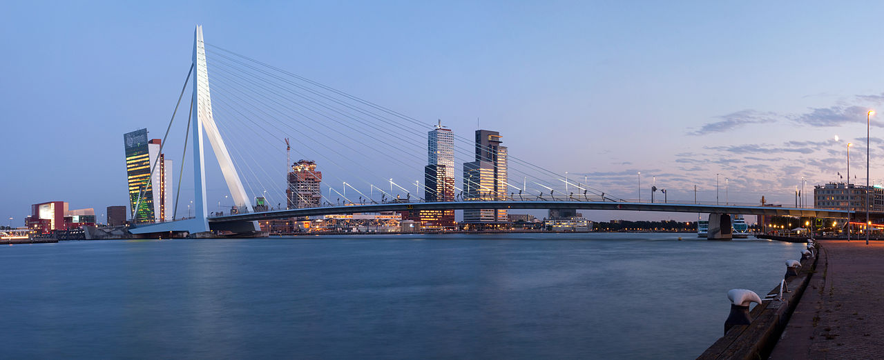
Image credit: A panorama of the Erasmus Bridge and the River Meuse in the Dutch city of Rotterdam. Photo by Massimo Catarinella. CC BY 3.0 via Wikimedia Commons.
As we gear up for the conclusion of the 2014 FIFA World Cup, we’re highlighting some interesting facts about the final four competing nations with information pulled right from the pages of the latest edition of Oxford’s Atlas of the World. Argentina and the Netherlands battled it out in a semi-final match on Wednesday 9 July; Argentina pulled through after a penalty shootout. The team will go head-to-head with Germany on Sunday, 13 July to determine the champion.
Argentina, a two-time World cup winner reached its fifth final when it defeated the Netherlands. The last time it had advanced that far was 24 years ago in 1986. To celebrate their achievement, here are a few facts to think about until then next Cup.
In 2007 Cristina Fernández De Kirchner was the first directly elected woman president in Argentina. She succeeded her late husband, Néstor Carlos Kirchner, who had previously served for four years. She was later reelected in 2011.
The country had a large indigenous population prior to European colonization; however 86% of Argentina’s population is now of European ancestry.
Argentina is South America’s second largest nation after Brazil, and the world’s eighth largest country. It is the fourth largest Spanish-speaking nation in the world.
Spain took control of Argentina in the 16th century and continued its reign until 1816, when the country won back its independence. Argentina later suffered from instability and periods of military rule.
The World Bank classifies Argentina as an “upper-middle-income” developing country. Its form of currency is the Argentine Peso which is equivalent to 100 centavos.
In 1991, Argentina, Brazil, Paraguay, and Uruguay set up an alliance, Mercosur, aimed at creating a common market. The agreement’s main purpose is to facilitate free trade.
Roman Catholicism accounts for a whopping 92% of the country’s population (Pope Francis was born and raised there). Protestantism and Judaism tie at a distant second making up 2% each of the population.
Oxford’s Atlas of the World – the only world atlas updated annually, guaranteeing that users will find the most current geographic information — is the most authoritative resource on the market. The milestone Twentieth Edition is full of crisp, clear cartography of urban areas and virtually uninhabited landscapes around the globe, maps of cities and regions at carefully selected scales that give a striking view of the Earth’s surface, and the most up-to-date census information. The acclaimed resource is not only the best-selling volume of its size and price, but also the benchmark by which all other atlases are measured.
Subscribe to the OUPblog via email or RSS.
Subscribe to only geography articles on the OUPblog via email or RSS.
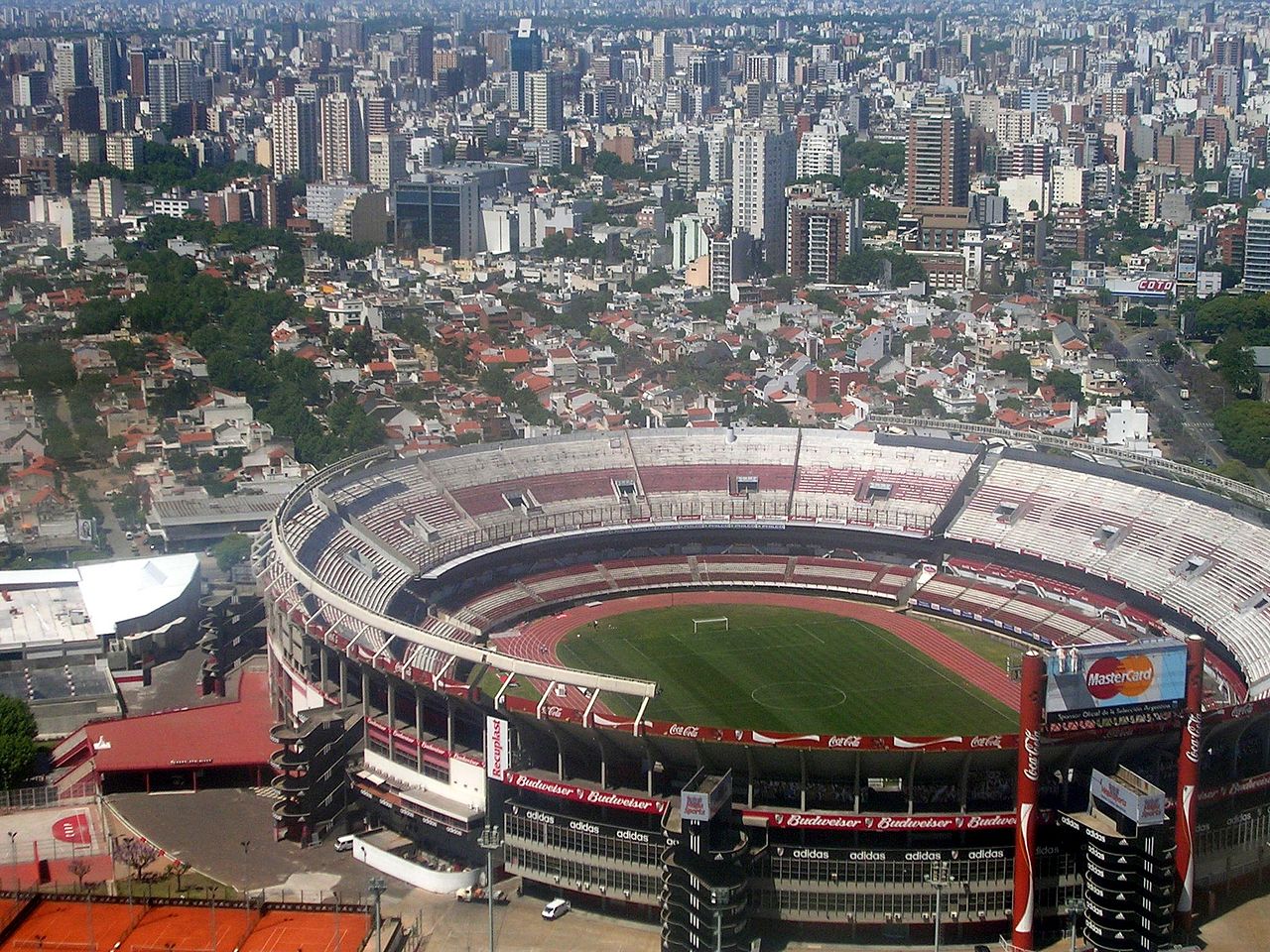
Image credit: Buenos Aires desde el cielo (Estadio de River). By Elemaki. CC BY 3.0 via Wikimedia Commons.
As we gear up for the conclusion of the 2014 FIFA World Cup, we’re highlighting some interesting facts about the final four competing nations with information pulled right from the pages of the latest edition of Oxford’s Atlas of the World. If you’re one of the few who hasn’t caught onto World Cup fever, the winner of the World Cup is near! Brazil and Germany faced off on Tuesday, 8 July. The shocking game left Germany the victor, with Argentina and the Netherlands battling it out on Wednesday 9 July. Argentina pulled through after a penalty shootout. The third place finalist will be determined on Saturday, 12 July with the final two teams going head-to-head on Sunday, 13 July to determine the champion.
The Federative Republic of Brazil, also known by the spelling Brasil, the world’s fifth largest country with a population of over 199 million, has the honor and distinction of hosting the World Cup this year, a fact that had this fútbol-centric nation even more hyped than usual.
A large country of over 3 million square miles, the area contains three main regions. Manaus, one of the host cities, has high temperatures all throughout the year. A tropical climate, rainfall is normally heavy, but lucky for players and cheering fans, the weather tends to be a bit drier from June through September.
Brazil is a leading economy in South America, described as a “rapidly industrializing economy.” You might not know that is the world’s top producers of products including cars, paper, aircrafts, and even materials ranging from diamonds to tin. With coffee as it’s leading export, agriculture employs 16% of the population. A major farming nation, products also include bananas, coca, rice, sugarcane, and maize.
With the Amazon, the world’s second largest river, in its backyard, forestry is a major industry although the fear that destroying the rainforests can accelerate global warming is a real concern. On a positive environmental note, Brazil is the second highest producer of hydroelectricity in the world, accounting for 12.3% of total world production.
Politically, the nation sets an example for progress in gender equality, having elected its first female president, Dilma Rousseff of the Workers Party, in 2010. It’s government is a Federal Republic, having first declared itself an independent empire in 1822 after originally being claimed by Portugal in 1500. After periods of material rule from the 1930s, civilian rule was restored in 1985 with a new constitution adopted in 1988.
Oxford’s Atlas of the World – the only world atlas updated annually, guaranteeing that users will find the most current geographic information — is the most authoritative resource on the market. The milestone Twentieth Edition is full of crisp, clear cartography of urban areas and virtually uninhabited landscapes around the globe, maps of cities and regions at carefully selected scales that give a striking view of the Earth’s surface, and the most up-to-date census information. The acclaimed resource is not only the best-selling volume of its size and price, but also the benchmark by which all other atlases are measured.
Subscribe to the OUPblog via email or RSS.
Subscribe to only geography articles on the OUPblog via email or RSS.
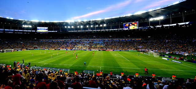
Image credit: Photo by Digo_Souza>, CC BY 2.0 via Flickr
School might be out for the holidays, but there’s still lots to learn. Since education never ends, we’ve prepared this geography quiz drawn from facts from the Oxford Atlas of the World, 19th edition. The only atlas to be updated annually, Oxford’s Atlas of the World combines gorgeous satellite images with the most up-to-date geographic and census information.
Oxford’s Atlas of the World — the only world atlas updated annually, guaranteeing that users will find the most current geographic information — is the most authoritative resource on the market. The Nineteenth Edition includes new census information, dozens of city maps, gorgeous satellite images of Earth, and a geographical glossary, once again offering exceptional value at a reasonable price.
Subscribe to the OUPblog via email or RSS.
Subscribe to only geography articles on the OUPblog via email or RSS. Image credit: From Atlas of the World, 19th edition.
Since its inception in 2007, Oxford University Press’s Place of Year has provided reflections on how geography informs our lives and reflects them back to us. Adam Gopnik recently described geography as a history of places: “the history of terrains and territories, a history where plains and rivers and harbors shape the social place that sits above them or around them.” An Atlas of the World expert committee made up of authors, editors, and geography enthusiasts from around the press has made several different considerations for their choices over the years.
Warming Island was a new addition to the Atlas and conveyed how climate change is altering the very map of Earth. Kosovo’s declaration of independence not only caused lines on the map to be redrawn, but highlighted the struggle of many separatists groups around the world. In 2009 and 2010, we looked to the year ahead — as opposed to the year past — with the choices of South Africa and Yemen. Finally, last year was an easy choice as South Sudan joined us as a new country.
We took a slightly different tact with Place of the Year this year. In addition to the ideas of our Atlas committee, we decided to open the choice to the public. We created a longlist, which was open to voting, and invited additions in the comments. After a few weeks of voting, we narrowed the possible selections to a shortlist, also open to voting from the public.
Four front-runners emerged in both the longlist and shortlist: London, Syria, Burma/Myanmar, and Mars. These places have changed greatly over the years, but 2012 has been a particularly special year for each. London hosted the Queen’s Jubilee and the Summer Olympics, as well as the Libor scandal and Leveson Inquiry. The Arab Spring has spread across the Middle East and North Africa, but after the toppling of dictators in Egypt, Libya and Tunisia, civil war threatens to tear Syria apart. On the other side of the globe, the government of Burma (also known as Myanmar) is slowly moving to reform the country and only two weeks ago President Barack Obama made a historic visit to Rangoon. And finally, this August the Curiosity Rover landed on Mars. Although you can’t find Mars in our Atlas of the World (for obvious reasons), it captures the spirit of cartography: the exploration of the unknown and all that entails.
It was these four front-runners that we asked Oxford University Press employees to vote on and our Atlas committee to consider. Mars won the public vote, the OUP employee vote, and the hearts and minds of our Atlas committee.
Once we made our final decision on November 19th, we began contacting experts on Mars from around Oxford University Press to illuminate different aspects of the red planet. Inevitably, the first response we received asked us whether we had heard about the rumours surrounding NASA’s upcoming announcement. We took that as a good sign — and we’ll bring up An Atlas of Mars at our next editorial meeting.
Oxford’s Atlas of the World — the only world atlas updated annually, guaranteeing that users will find the most current geographic information — is the most authoritative resource on the market. The Nineteenth Edition includes new census information, dozens of city maps, gorgeous satellite images of Earth, and a geographical glossary, once again offering exceptional value at a reasonable price.
Subscribe to the OUPblog via email or RSS.
Subscribe to only geography articles on the OUPblog via email or RSS.
0 Comments on How we decide Place of the Year as of 12/3/2012 10:09:00 AM
The 4 July discovery announcement makes it clear that the new particle is consistent with the long-sought Higgs boson. The next step is therefore reasonably obvious. Physicists involved in the ATLAS and CMS detector collaborations at the LHC will be keen to push ahead and fully characterize the new particle. They will want to know if this is indeed the Higgs boson.
How can they tell?
I mentioned in the third post in this series that the physicists at Fermilab’s Tevatron and CERN’s LHC have been searching for the Higgs boson by looking for the tell-tale products of its different predicted decay pathways. The current standard model of particle physics is used to predict the rates of production of the Higgs boson in high-energy particle collisions and the rates of its various decay modes. After subtracting the ‘background’ that arises from all the other ways in which the decay products can be produced, the physicists are left with an excess of events that can be ascribed to Higgs boson decays.
Now that we know the new particle has a mass of between 125-126 billion electron-volts (equivalent to the mass of about 134 protons), both the calculations and the experiments can be focused tightly on this specific mass value.
So far, excess events have been observed for three important decay pathways. These involve the decay of the Higgs boson to two photons ( H → γγ), two Z bosons (H → ZZ → ι+ι-ι+ι-) and two W particles (H → W+W- → ι+υ ι-υ). You will notice that these pathways all involve the production of bosons. This should come as no real surprise, as the Higgs field is responsible for breaking the symmetry between the weak and electromagnetic forces, giving mass to the W and Z particles and leaving the photon massless.
The decay rates to these three pathways are broadly as predicted by the standard model. There is an observed enhancement in the rate of decay to two photons compared to predictions, but this may be the result of statistical fluctuations. Further data on this pathway will determine whether or not there’s a problem (or maybe a clue to some new physics) in this channel.
But the Higgs field is also involved in giving mass to fermions (matter particles, such as electrons and quarks). The Higgs boson is therefore also predicted to decay into fermions, specifically very large massive fermions such as bottom and anti-bottom quarks, and tau and anti-tau leptons. Bottom quarks and tau leptons (heavy versions of the electron) are third-generation matter particles with masses respectively of about 4.2 billion electron volts (about 4 and a half proton masses) and 1.8 billion electron volts (about 1.9 proton masses).
These decay pathways are a little more problematic. The backgrounds from other processes are more significant and considerably more data are required to discriminate the background from genuine Higgs decay events. The decay to bottom and anti-bottom quarks was studied at the Tevatron before it was shut down earlier this year. But the collider had insufficient collision energy and luminosity (a measure of the number of collisions that the particle beams can produce) to enable independent discovery of the Higgs boson.
ATLAS physicist Jon Butterworth, who writes a blog for the British newspaper The Guardian, recently gave his assessment:
If and when we see the Higgs decaying in these two [fermion] channels at roughly the predicted rates, I will probably start calling this new boson the Higgs rather than a Higgs. It won’t prove it is exactly the Standard Model Higgs boson of course, and looking for subtle differences will be very interesting. But it will be close enough to justify [calling it] the definite article.
When will this happen? This is hard to judge, but perhaps we will have an answer by the end of this year.
Subscribe to the OUPblog via email or RSS.
Subscribe to only physics and chemistry articles on the OUPblog via email or RSS.
View more about this book on the
0 Comments on What happens next in the search for the Higgs boson? as of 1/1/1900
It’s a place that seems to be on the brink of collapse, and even as we prepared to make this announcement, Yemen again emerged as a home base for terrorist plots. The stakes are high and the future is unclear for Oxford’s 2010 Place of the Year.
According to geographer Harm de Blij, author of The Power of Place and Why Geography Matters, “In the modern world of terrorist cells and jihadist movements, Yemen’s weakness spells opportunity.” Regional conflicts like the Houthi rebellion in the north and revival of the southern secessionist movement diminish the power of the government. Terrorist bases now reside in the remote countryside, posing a familiar dilemma for the United States: Is shoring up the country’s army and police worth the risk of increasing Al Qaeda protection and loyalty? At the same time Yemen stands to be the poorest country in the Arab world, nearly depleted of its leading export, oil, while facing a water shortage experts say is heighten by the country’s addiction to qat, a mildly narcotic leaf.
Once a promising experiment in Muslim-Arab democracy, Western opinion now recognizes Yemen to have all the features of a failed state. Obscured by the attention of the political geography, is what de Blij calls “a Yemen that might have been.”
To hear more from de Blij on Place of the Year be sure to check in tomorrow!
Yemen at a glance:
Population: 22,858,000
Capital(s): Sana’
Government: Multiparty Republic
Ethnic Groups: Predominantly Arab
Languages: Arabic
Religions: Islam
Currency: Yemeni rial= 100 fils
Cash crops: coffee and cotton
President: Ali Abdullah Saleh
And now for the runners-up…
Greece
Haiti
Gulf Coast (of the United States)
the Eyjafjallajokull volcano
Mexico
Seaside Heights, NJ
California
Rio de Janeiro
Wall Street
The Gulf of Aden (“Pirate Alley”)
OUP Employee Votes:
“I’d go with Mexico. A fascinating failing state in which our stake couldn’t be greater, and compelling for all the reasons the other places mentioned might be interesting (or in crisis) individually–you have natural disaster (or the ongoing potential thereof), man-made disaster, social unrest, crime (and how), political chaos and corruption, etc. Whatever you do, don’t pick Seaside Heights, N.J., though I’ve nothing whatever against the place.” -Tim Bent, Executive Editor, Trade History
“Haiti—so we don’t forget the hundreds of thousands of people who lost their families and homes and way of life.” -Jessica Ryan, Copyediting Lead
“Eyjafjallajokull. It’s perfect in that it had a world-wide impact, or close to it; it was hard to pronounce; and it was the proverbial flash-in-the-pan issue.” -Niko Pfund, VP and Publisher
“You totally made up that v
0 Comments on And the Place of the Year is… as of 11/1/2010 7:56:00 AM
Everyone has a favorite place in the world. Mine happens to be on that most derided of beaches, the Jersey Shore. (Thanks, Snooki.) I love escaping the gridlock and heat of Manhattan to the peaceful Shore, with its beautiful beaches, tons of activities—biking, crabbing, beach volleyball, fireworks watching, to name a few—and excellent ice cream. It’s just a short trip from New York, but feels like a different world.
Traveling there is easy: just hop on New Jersey Transit from Penn Station. Traveling across the world, though, is never a breeze. Just as everyone has a place they love to escape to, everyone knows what a pain it can be to get there. In anticipation of the quickly approaching summer, below are some tips from Oxford editorial staff and authors on the best ways to get around the world—or, if you’re not sure where you’re headed yet, tips on where to go!
Amber Fischer, Senior Editor, Oxford Art Online and Oxford Music Online: Pokhara is definitely worth a visit if you’re in Nepal and is a relaxing alternative to Kathmandu….Or try Wolsey Lodges if you’re looking for something different. Mostly in the UK (although there are also some in France and Spain), they are mostly beautiful, grand, historical homes where the owners choose to rent out a room or two to travelers. You get luxury (or at least really cool and historical) accommodations for usually 45-85GBP per night, and you’re almost always invited to dine with the owners, who always seem to be down-to-earth and friendly.
William Beezley, Editor of the Oxford History of Mexico: For absolutely excelente lunches with reasonably priced wine go to the Casino Español in Mexico City. I go at least once on every trip. A delightful museum is the Museo de Arte Popular, a new museum with excellent examples of popular art of all kinds and a good bookstore and coffee shop. The building was once a fire department.
Mary Funchion, Development Editor, Reference: Before I book an airline ticket, I use Kayak.com. It compares all the airlines and lets you know which ticket is the cheapest option. You have to leave the site to actually book the ticket, but it saves having to g
The Klencke Atlas is 350 years old and it is the biggest book in the world. It is 5 feet tall and 6 feet wide. The atlas was a gift to an English king, Charles II, 350 years ago. Six people are needed to just to lift the book--that's some heavy reading.
For the very first time in 350 years, the atlas is going to be on public display at the British Library. The display will highlight 100 maps, showing off their wonderful artwork.
If you wanted to make a book as huge as the Klencke Atlas, what would the book be about? Think about how big you would need to make the book mark for such a book. And how would you read the Klencke Atlas? You certainly couldn't hold it on your lap.
Just some interesting book stuff for Friday...what are you reading this weekend???
0 Comments on The Biggest Book in the World as of 1/1/1900
I dare you to watch the trailer for this December’s Invictus—the story of how a newly elected Nelson Mandela used the 1995 Rugby World Cup to bring his people together—without feeling slight heart palpitation. Particularly in a scene where we see Mandela speaking with a political confidante:
“This rugby, it’s a political calculation,” she says.
“It is a human calculation,” responds Mandela.
Sounds like one awfully loaded conversation about rugby, but if there’s anything history, cinema, and Nike commercials have taught us, it’s that the game ultimately represents something much bigger than itself. From taking a stand (1980 Moscow Games boycott) and breaking social barriers (Jackie Robinson, Dara Torres) to beating odds (Nancy Kerrigan, Lance Armstrong) and growing up (Mighty Ducks 1, 2, and 3), sports are often the metaphors and inspiration of our lives. Which leads us to our big announcement… as it moves to the forefront of the global sports arena once more, we are excited to announce South Africa as Oxford’s “Place of the Year.” The 2010 World Cup—arguably the most important international event the country will host since officially becoming a post-apartheid, democratic nation only 15 years ago—signifies further transformation, quantifiable in millions of dollars worth of new infrastructure.
How much new infrastructure?
According to FIFA, contributions from the South African government total (in rands “R”):
Stadium and precinct development: R9.8 billion
Transport: R13.6 billion
Broadcast and telecommunications: R300 million
Event operations: R684 million
Safety and security: R1.3 billion
Event volunteer training: R25 million
Ports of entry infrastructure: R3. 5 billion
Immigration support: R630 million
Communications, hosting, legacy and culture: R504 million
Which translates to…
According to consulting firm Grant Thornton, which drew up the financial impact report for South Africa’s World Cup bid committee:
R55.7 billion to the South African economy
415,400 jobs
R19.3 billion in tax income to the government
I’m writing you today with some sad news about the Place of the Week column. Ben Keene, Oxford’s geography editor and the founder of Ben’s Place of the Week, has left Oxford. For the last three years, Ben has done a superb job combing the globe in order to bring a particularly delightful, unusual, or timely locale to our attention, often with a humorous and graceful touch. I’m sure you share in my feeling that Ben’s love of geography has been contagious, and that the world now seems just that much smaller and friendlier to us all. The Place of the Week is now on hiatus and I will let you all know if we have the opportunity to start it up again in the future.
Safe travels,
Casper Grathwohl
Publisher
1 Comments on Place of The Week, last added: 2/21/2009
Thanks for the acknowledgment Casper! It was an enjoyable assignment and one I’ll miss. For those web readers who find themselves in need of a daily dose of geography, travel, and a bit of wry humor for good measure, I’d encourage you to check out World Hum, a site I contribute to frequently.
Today the world turned its eyes to Washington, DC where the United States inaugurated its 44th President, Barack Hussein Obama. And while most of our executives have been sworn in here on the banks of the Potomac, our first head of state actually took office a stone’s throw from another river: the Hudson. On April 30, 1789, George Washington took his oath of office in front of a crowd assembled on Wall Street in lower Manhattan. After a long trip from his home in Virginia, he was rowed to New York and walked to Federal Hall, the site of his inauguration and the birthplace of American government. At the time, the city’s inhabitants numbered roughly 30,000, and its homes and businesses did not extend much further than the modern location of Canal Street. Just ten years later, the population of the country’s first capital had swelled to more than 60,000 residents.


 Make sure to vote for your Place of the Year below. If you have another Place of the Year that you would like to nominate, we’d love to know about it in the comments section. Follow along with #POTY2014 until our announcement on 1 December.
.jpg#mediaviewer/File:CERN_Control_Center_(2).jpg)


 Jim Baggott is author of
  peaceful Shore, with its beautiful beaches, tons of activities—biking, crabbing, beach volleyball, fireworks watching, to name a few—and excellent ice cream. It’s just a short trip from New York, but feels like a different world.
.jpg?picon=993)


Thanks for the acknowledgment Casper! It was an enjoyable assignment and one I’ll miss. For those web readers who find themselves in need of a daily dose of geography, travel, and a bit of wry humor for good measure, I’d encourage you to check out World Hum, a site I contribute to frequently.